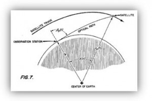
With the launch and tracking of Sputnik in 1957, it soon became obvious that the location of the satellite could be tracked by monitoring its Doppler shift. Frank McClure persuaded fellow researchers at Johns Hopkins Applied Physics Lab to devise a satellite navigation and positioning system based on the Doppler shift of satellite signals. [1] The team, led by Richard Kershner, developed the first satellite positioning system: the US Navy’s Transit constellation (also known as NAVSAT). Transit provided up to 100 m location accuracy. [2] Due to coverage limitations, the 10-15 minute processing time required for a position, and position inaccuracies, the DoD sought an alternative solution and formed the GPS Joint Program Office.
Testing for GPS continued throughout the 1970’s and 1980’s with the full constellation of 24 satellites coming on line in 1995. GPS operates by time of flight principles with precise ephemeris, timing synchronization, and a variety of corrections including atmospheric and relativistic effects. The satellites are placed in geosynchronous orbit and can provide global location metrics with measured accuracies within 9 m (95% confidence) or better. The primary limitation of the current GPS system is that the microwave signals are largely blocked indoors and vulnerable to multipath in urban canyons. [3]
[1] Frank T. McClure, Method of navigation, US Patent 3,172,108, March 2, 1965.
[2] B. Parkinson, “A History of Satellite Navigation,” NAVIGATION: Journal of Navigation, 42, 1, 1995, pp. 109-164.
[3] E. Kaplan, Understanding GPS: Principles and Applications, (Boston: Artech House, 1996), p. 237


2 thoughts on “RTLS: Global Positioning System (GPS)”